The Polychrome Slump
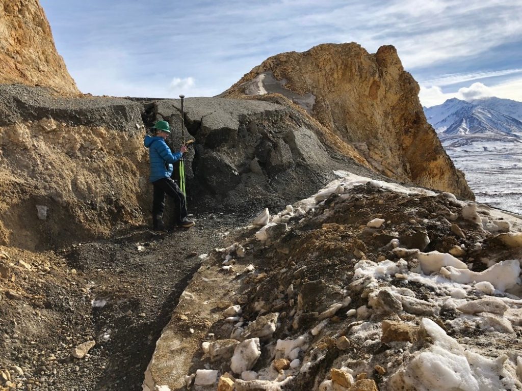
Park geologist Denny Capps headlined the DCC annual meeting on June 8 to discuss the issue that is at the forefront of Denali concerns this year: the slumping road bed just east of the Pretty Rocks section of the Polychrome “High Line.” While it is a longstanding issue, this slump has affected the park road more significantly in recent years than in prior years. For decades, starting in the 1980s, road maintenance personnel would haul in enough Toklat crushed material at the start of the season to raise the road the 6-18 inches that it had slumped after the end of the prior season of traffic. The pronounced dip in the road was mitigated somewhat during the later 1980s by deepening the cut in the stable ground at the corner just east of the slump. Another approach to mitigating the angle of the dip was to add enough material to bring the road up to near level with the stable platforms on either side.
According to the park’s website, the annual slumping increased to 2.6 feet in 2016, doubled in 2017, and increased to 12 feet by the time the snow removal crew reached the site in late March 2019. According the park geologist Denny Capps, the slumping through the end of July 2019 is “steady” at 12-14 feet per year.
The slump is part of an active slide, starting hundreds of feet above the road and descending 800 feet down to the floodplain of the East Fork River. The loose slide material on the surface covers ice-rich/ice-cemented loose material below. The rock type is rhyolite, the extrusive version of igneous material that when intrusive is granite. Higher summer temperatures, as Alaska has been seeing this century, have undoubtedly reached and melted more of the ice uphill and below the road, leading to volumetric subsidence and sliding of loose material along the steep wet-icy planes at depth.
The potential disruption of the slump to vehicle traffic on the road has alarmed park management, which has led to additional research funded by the congressional appropriations to the Federal Highways Administration. FHWA placed inclinometers into augured holes in the area in 2017, to find most of them busted by slumping within weeks. Monuments have been placed in the area for a standard survey approach, but a high-grade monitoring system of 30 reflectors and a permanent, remotely-controlled “total station” are being placed in late summer to detect changes at the slump in real time. Seeing movement in real time could alert rangers or maintenance to deal with rockfall or other issues before buses arrive in the morning.
Senator Lisa Murkowski has also taken an interest. She has requested that the park provide quarterly updates on the situation and further planning. The text from the first Quarterly Report is on the park’s website, and the second report has been written and is presently being reviewed in the NPS regional and national offices.
NPS has developed a first-run set of alternatives for addressing the problem at Pretty Rocks which is posted on the park website: https://www.nps.gov/dena/learn/nature/pretty-rocks.htm
An investigation into why the Polychrome High Line route was chosen for the park road alignment was made available in June 2019: https://www.nps.gov/dena/learn/nature/upload/High-Line-Decision-6-24-2019-EJ.pdf
A related issue for some of the proposed alternatives is the Mile 45 or “Bear Cave” slump. Both the South and North “Reroute Options” would bypass both the Pretty Rocks slump and the Mile 45 slump. The Mile 45 slump also reaches all the way down to the East Fork River and is being eaten away at the base by the river faster than the Pretty Rocks slump. The Mile 45 slump was noticed in the 1980s to be losing material at its headwall and moving to within 30 feet of (below) the road. In 1990 the park removed a culvert that was draining directly into the top of the slump and a few years later had a contractor cut down 6’ in the ditch line above the road (in April when the ground was still frozen) and install a gravel-filled fabric “burrito” for about 200 yards adjacent to the road to carry subsurface water away from the roadbed to the next relief culvert. Repeated surveys since 1990 have found some movement in the slump below the road though the headwall position seems to be relatively steady.
According to Denny Capps the “Rebalance” option described on the website is the type of option favored by the Alaska Department of Transportation and Public Facilities. It would require bringing down as much loose material from above the road – and from the road location itself – to “overboard” it below the road. This option would involve moving potentially hundreds of thousand of cubic yards of material. It would likely proceed in stages, depending on how thick horizontally the slide is, what equipment operator safety issues had to be addressed, and where stable ground could be found.
In addition to the new monitoring instrumentation, 2019 will see drilling east and west of the slump to characterize the soundness of those sites for potentially constructing a bypass bridge.
Article by Steve Carwile
