Make your voice heard – ASAP Gas pipeline comments due October 14, 2014
On August 1, 2014 the US Army Corps of Engineers announced a public comment period for the Alaska Stand Alone Pipeline Project (ASAP). Comments are due by October 14, 2014. Although an initial Environmental Impact Statement (EIS) was approved in October of 2012, this scoping period will help to develop a Supplemental EIS to address changes in the pipeline right-of-way, and facilities on the North Slope to prepare gas for transport in the pipeline. Click here for more information on the Supplemental EIS.
DCC submitted extensive comments on the initial EIS, and will be submitting detailed comments during this scoping period as well. Interested parties are encouraged to submit comments ensure that the concerns of local residents are addressed.
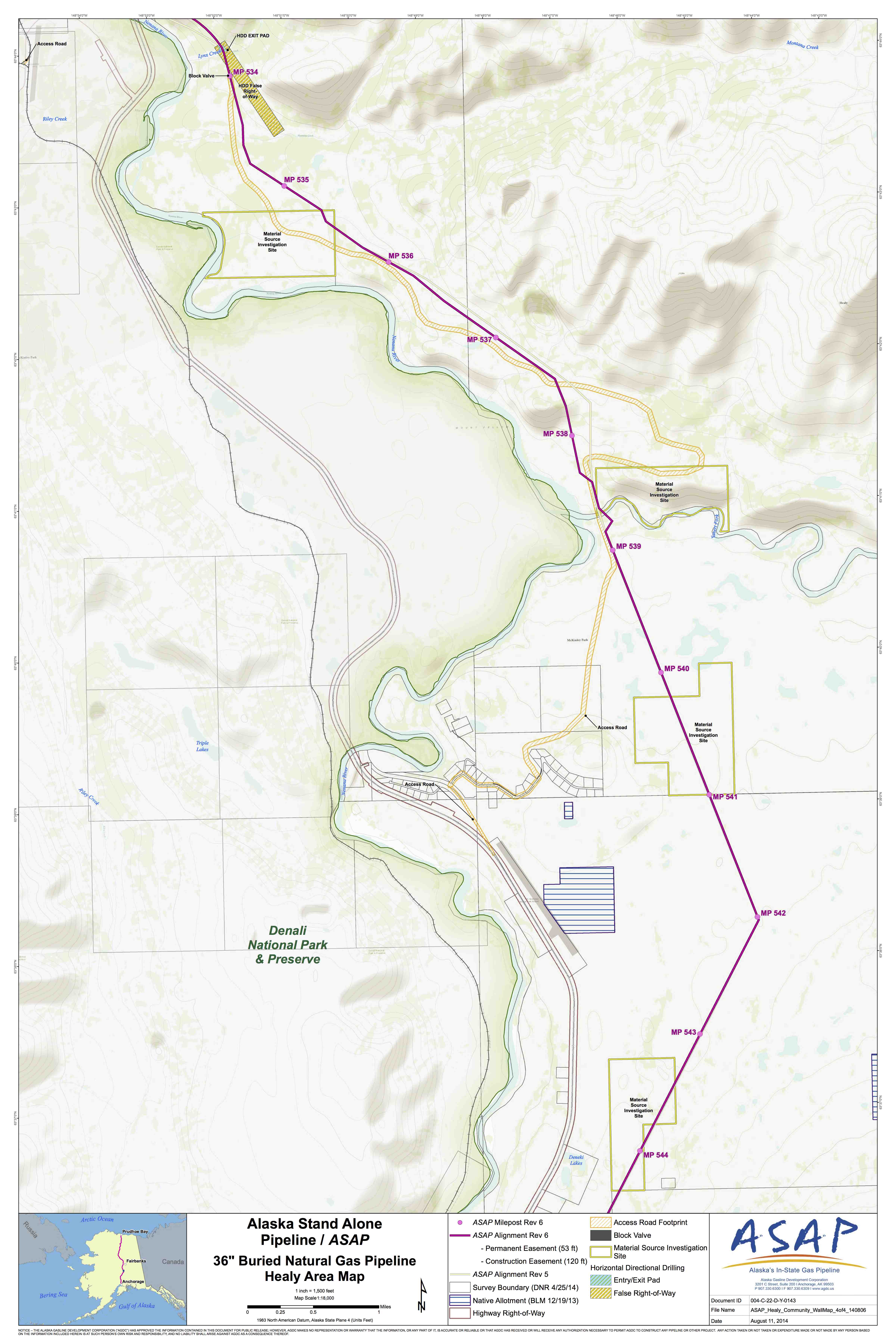
The route of this line has changed several times, and is proposed to travel through residential areas, and valued natural areas. Check the maps available online for current projected locations of the line in relation to your property and places where you work and recreate. Detailed maps can be viewed under the headings of Healy and Cantwell.
Your comments on the Supplemental EIS are due October 14, 2014. Comments can be submitted by email to asapeiscomments@usace.army.mil.
Feel free to copy and paste the following information in developing your comments. Personalized comments are usually given more attention. Add any information that addresses your areas of concern!
- The Supplemental Environmental Impact Statement (SEIS) should consider alternative routes along existing corridors (such as the Trans-Alaska Pipeline (TAPS) corridor, Richardson Highway and Parks Highway through Denali National Park and Preserve).
Giving the same amount of consideration for all alternatives in the SEIS will provide an opportunity for public review, and an opportunity for public comment specific to each alternative.
If along the Trans Alaska Pipeline corridor, the proposed ASAP pipeline could travel within 12 inches of the existing oil pipeline. Using the existing pipeline corridor would have substantially fewer negative impacts by avoiding the clearing and maintenance of an entirely new right-of-way. This should be considered.
- If the pipeline must travel along the Denali Bypass (Yanert) route or the Parks Highway corridor, rather than the TAPS corridor, additional measures must be included to reduce impacts.
Detailed information should be provided regarding access roads, water sources and material sites within the Denali Borough for all alternatives.
Detailed information should be provided on pipeline design in areas of high seismicity, including the Denali Borough, so that residents are given an accurate picture of what development is proposed. This should not be postponed or left up in the air, and should be a consideration for all alternatives.
Impacts to the view shed, particularly around Denali National Park should be considered for all alternatives, and should take into account whether the pipeline will be above or below ground.
A full-scale Health Impact Assessment should be required for a project of this size to address impacts to individual and community health.
- Local input most be considered and deemed highly important, since the route in the vicinity of the Parks Highway corridor will have substantial negative impacts and no clear benefits to locals.
Avoid sensitive areas and undeveloped land such as around the Yanert This area in particular has a long history of importance to local residents (recreation, non-motorized hunting opportunities, and innumerable other values).
Do not use the Yanert Road for any part of this project.
Avoiding the Parks Highway to travel around Denali National Park and Preserve ignores federal legislation (Denali National Park Improvement Act, S. 157) intended to provide an option that would be comparable to a Richardson Highway alternative (in an existing transportation corridor). Consideration of impacts should include comparison of a route within the existing Parks Highway (through Denali National Park and Preserve) and Richardson Highway right-of-ways, as well as the proposed Denali Bypass.
Residential lands surround the Parks Highway within the Denali Borough. As proposed, the current ASAP alignment and associated access roads deviate from the Parks Highway alignment and through concentrated residential areas.
Contact Hannah Ragland (hannah@denalicitizens.org) with any questions or to request additional information.
