Pretty Rocks Underway – Questions Linger
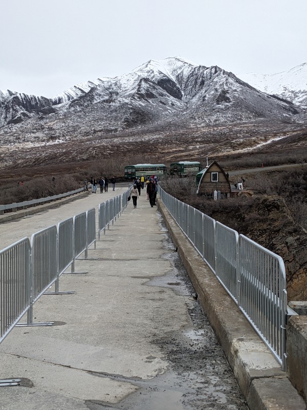
Photo: The scene at East Fork Bridge looking east in early June
The second season for Denali to operate with the road closed at East Fork bridge is about halfway over. With construction at Pretty Rocks pending, the National Park Service has kept the road beyond East Fork closed to pedestrians and cyclists. Visitors wanting to see the park beyond the bridge are using the installed staircase on the west side of the bridge to access the East Fork gravel bar and hiking from there, although there are exceptions from Kantishna fly-ins to hardy cyclists who wheel their bikes up the gravel bar until they can rejoin the road past Polychrome Rest Area.
NPS is providing periodic updates about the status of the project on its blog site at https://www.nps.gov/dena/blogs/pretty-rocks-construction.htm.
The Federal Highway Administration, which is managing the project for NPS, is also providing regular updates on the project website at https://highways.dot.gov/federal-lands/projects/ak/polychrome-area-improvements.
Denali Citizens Council feels that there are a lot of questions about the project that still have not been fully answered, particularly as it has evolved. We recently sent a letter to Denali Superintendent Brooke Merrell asking a lot of these questions. Most of the them are answered in an NPS email response copied below, however NPS notably did not respond to our suggestion for holding a public informational meeting this summer. You can read the complete DCC letter by clicking the link.
Here are the specific questions and responses, with DCC’s questions in boldface and NPS’s responses in the blue boxes.
In the Section 106 consultation letter we received it was indicated that the contractor is wishing to use a particularly historic section of the park road – what Tom Walker calls the “Pioneer Curve” (mile 45.6) – for staging materials and equipment. We thought this staging was going to take place at Polychrome Overlook. Can you clarify why the contractor needs to move to a more sensitive site?
The Polychrome Overlook was deemed unsuitable for staging the needed volume of material due to geotechnical stability concerns. Mile 45.6 was selected as an alternative location because it is close to where the excavated material will be removed from the Pretty Rocks site and will result in less time spent transporting material for use later in the construction project, thus improving the overall efficiency of the project. Its proximity is also ideal for staging a crane that will be used for excavation and bridge foundation construction on the west side of the slide. Your concerns regarding the sensitivity of the cultural resource at Mile 45.6 were considered and as a result, additional measures will be taken to ensure that it will be returned to pre-construction condition after the project is completed.
Now that the contractor is on site, has a determination been made about how to get equipment to the west side of the slump? We have asked about this before, and there has never been a firm plan. The same Section 106 consultation letter indicates that the contractor intended to access the west side through an area “so steep that a pedestrian survey is not possible.” That seems like it would be an extremely hazardous way to access the west side of the site. The consultation letter also indicates that 3 acres of “non-vegetated wilderness” would be added to the project area. Is that a full 3 acres of Congressionally designated wilderness? If a portion of the Denali Wilderness is included, could we see the Minimum Requirement Determination for the change?
The contractor will determine the most feasible way to access the west side. Their current plan is to drive heavy equipment down onto the hillside below the east knob and across the landslide and therefore the project area was expanded to accommodate this initial equipment access route. The additional three acres are fully within federally-designated wilderness. However, a new Minimum Requirement Analysis (MRA) is not needed since the actions occurring in the expanded project area are still within the scope of the MRA associated with the Polychrome Area Improvements EA. The wilderness impacts of this change are documented in a Categorical Exclusion that has been made available to the public on PEPC as of July 31st, 2023.
Also, given the extended timeline and the significant increase in dirt work for the project, is the cost also going to go up? And if so, how will NPS/FHWA pay for it? What is the maximum that NPS is willing to invest in this project before it just looks too absurd?
The cost was last estimated at $130 million, with funding secured through the Bipartisan Infrastructure Law, 2022 Disaster Relief Supplemental Act and our Federal Lands Transportation Funding via the latest surface transportation act. Through this active funding, Congress is demonstrating support for continued road access to these federal lands. As you note, the increased timeline will mean increased costs to that amount, with a final negotiated amount expected near the end of the month. The increase in cost to this project exceeded what are now outdated contingency assumptions, but construction projects across the country are experiencing similar dramatic increases. For that reason, the increase for this project in particular has not generated surprise at the national level.
We have heard that you have the final bridge design now. Can you share that?
The 100% bridge design was provided to NPS for review, but it has not been finalized. However, the 70% designs were used to create detailed visuals for the public that portray the prominent bridge features, which have not changed substantially since then. These are available on our project webpage. We will seek to provide a similar level of information on the webpage for the final design.
With the final design and contractor input, what deviations are there from the project as described in the EA?
A summary of the design changes was previously shared via email in Sept 2022, and the impacts of those changes are documented in a Categorical Exclusion that has been made available to the public on PEPC as of July 31st, 2023.
Are NPS and FHWA still confident that this project will have a lifespan of 50 years? The news about climate change is increasingly dire, and we wonder if the thermo-siphons on a south-facing slope will really be able to keep the permafrost frozen over the next several decades.
The best, latest technology is being used to offer the longest lifespan of this project. Three-dimensional thermal modeling (using the most up-to-date climate models extending through the year 2100) suggests that the thermosiphons will maintain the permafrost under the east abutment well below freezing throughout the duration of the design life of the bridge. Additional condensers can be added to the thermosiphons as needed, to keep the permafrost frozen.
Through our members, we hear that there is going to be further geologic research conducted at the Bear Cave site. Are there any new concerns there? What are present thoughts about the timeline for the Bear Cave project given the extended schedule for Pretty Rocks?
The solution to address the Bear Cave Landslide has not yet been fully designed and therefore additional geotechnical investigations will likely be needed as FHWA refines the design. However, there are no new concerns at the site, and no specific plans for additional drilling in that area this summer. The Bear Cave improvements are tentatively scheduled for 2025 but that timeline will likely be adjusted, based on the Pretty Rocks project schedule.
Without the excitement of walking up to the slide this year, are visitors still happy with the shortened road experience? Is NPS getting much positive or negative feedback from visitors traveling the park road?
Visitors are still able to explore other aspects of the East Fork area on foot and the park has received an unexpected number of positive comments on the Park Road experience to Mile 43. Plus, with a shorter bus ride, visitors seem happy to have more time to enjoy the frontcountry areas of the park.
Finally, what now is the timeline for the Ghiglione Bridge replacement?
The Ghiglione Bridge replacement is scheduled to start in 2027 and be completed in 2028.