Protecting the Road at Bear Cave Slump
by Steve Carwile Photo by NPS
Bear Cave. The name has an Alaskan feel to it, with the tall-tale angle that no evidence of bear use in the cave has been established. However, the cave was used as the shooting location for a pivotal scene in Sourdough, the 2nd best movie about Alaska, written in part by Rod Perry (who ran the first Iditarod) and which stars Rod’s father.
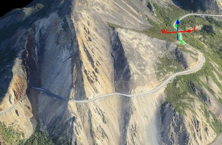
Bear Cave sits above the park road at Mile 45 on an east-facing slope. 25 feet below the road is the head of a large slumping landform that reaches almost 400 feet down to the main channel of the East Fork of the Toklat River. The road, of course, was originally routed on firmer ground above the slump, but the head of the slump gradually migrated upward toward the road. The park realized that a culvert channeling flow into the head of the slump was contributing to the slump’s lubricated movement, so in the spring of 1999 the culvert was removed and a Burrito Method French Drain was installed along the uphill side of the road in a new trench. The Burrito extended for hundreds of feet northeastward to reach another culvert that routed drainage beyond the slump. The migration of the head of the slump essentially stopped, though other movement of the slump body continued.
In 2022 the NPS approved the construction of the Polychrome Bridge, but also approved a Phase II project to protect the road by installing a 1000 foot long retaining wall to a depth of 30-60 feet just below the road at the Bear Cave curve. Stabilizing that wall would be several hundred piles driven into the ground. Projections were that the Bear Cave project would cost $53 million, $3 million more than the bridge estimate at that time.
In late June, 2025, the Park announced that it has recently moved away from the retaining wall concept at Bear Cave. The new plan is to realign about 700 feet of the park road 40 feet west (uphill) of where it is now, without creating impacts beyond the Wilderness boundary. New cut slopes above the re-aligned road would be stabilized: “…options include placing riprap, fabric, or other means of stabilization.” Other projects in Phase II to control rockfall at the 15 MPH corner east of Bear Cave and at the corner before the Bridge Project area were approved in 2022.
The evaluation of the revised Bear Cave project for compliance with the National Historic Preservation Act (the Park Road is on the National Register of Historic Places) continues the finding of an Adverse Effect found for the 2022 Bridge and Retaining Wall project. Mitigation agreed upon by the NPS and the State Historic Preservation Officer include “…the creation of a video based on the book “Snapshots From the Past” and through oral history interviews with road users.” The 2022 project Area of Potential Effect (an NHPA term of art) does not change with this proposed new realignment, so the mitigation agreed upon apparently is intended to fulfill the compensation for the Adverse Effect to the characteristics which qualified the park road for inclusion on the National Register.
We question, however, that the visual and other impacts from a buried retaining wall are equivalent to the impacts from a road realignment. In the 2022 project: “…the retaining wall at Bear Cave will be partially buried and therefore minimally visible.” In the 2025 project the realignment – on a quasi-wetland slope – will require significant excavation of sloping colluvium, both for the new roadway and for the cut slopes above. The new roadway will require a substantial amount of borrow material to create a stable and very visible road prism on the wet sideslope, and for the cover rock on the cut slope. Cover rock on the cut slope has only been installed along the park road at Mile 4 and at Mile 22.5. The old roadbed may be re-vegetated and would take years to blend in. The announcement of a NHPA review of the revised Bear Cave Project does not fulfil the broader public’s right to review and comment on the project proposal and evaluations under the National Environmental Policy Act. Once the Federal Highways Administration drafts project plans, the public should be given the opportunity to review those plans and comment on the proposed impacts to the historic character of the road. We await the Park’s sharing of that NEPA document.