Pretty Rocks Bridge: How Has the Project Changed?
By Steve Carwile. Photo by NPS.
Since the National Park Service and the Federal Highway Administration (FHWA) settled on a plan to bridge the Pretty Rocks landslide, the agencies have announced a number of changes regarding project construction, timeline, and cost. To get a sense for the overall scope of the changes, DCC reviewed each of the public announcements and itemized the key aspects of the project plan and the changes thereto, following the original FHWA plan from September 2020 and the Environmental Assessment (EA, January 2022) and accompanying Finding of No Significant Impact (FONSI, March 2022).
In summary, since the project approval the Polychrome Bridge project has:
1) Significantly increased in price, from $91,000,000 to $150,000,000, though that latter figure may only be for the new bridge, and not including most work at Bear Cave, east of the landslide.
2) Extended the project completion date from May of 2025 to July of 2026, thus keeping the park road closed at East Fork for at least one-and-a-half additional seasons (in addition to the 2022-2024 closure originally planned).
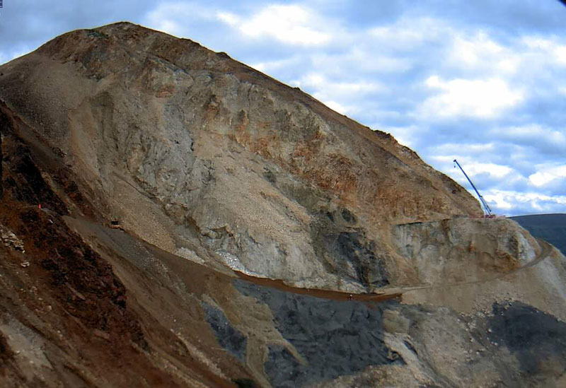
3) Added 3 acres of disturbance to designated wilderness in steep, rocky terrain to provide for a route to access the western side of the project area. A route to access the western side was not evaluated in the EA. The EA had identified ten acres of impacted wilderness on the lower landslide. A Categorical Exclusion reasoned that there would be no additional impacts from using an additional three acres of wilderness because there would/could be less overboarding of excavated material into wilderness than previously planned, so the previously approved 10 acres might not all be impacted. No map was given showing which three acres of landslide wilderness would not be impacted.
4) Added a formerly rejected slope control measure. The FONSI says that “rockfall barriers and draped rockfall protection mesh” were removed from the project design because they were “in conflict with NPS policies.” However, the 2023 design changes include that a “soil nail wall will be installed with a steel wire mesh.”
5) Added 5 acres of vegetated and historic areas adjacent to the road as gravel and equipment storage areas, saying that the resources would be made whole after the project. This area is known to the historically-minded as Pioneer Curve, and although now unused is one of the only places where the original 1930s-era road is still visible. This change is particularly concerning: taking 5 acres of parklands for an industrial use is not a common occurrence and should not be approved in a Categorical Exclusion – without public comment – by claiming “such changes would cause no or only minimal environmental impact.” DCC is dubious that the pre-project integrity of the historic resource can be successfully restored after the contractor uses it for 3 years.
6) Extended the project into additional wetlands which could involve additional regulatory scrutiny from the Army Corp of Engineers.
Detailed Timeline of Project Parameters and Changes
September 2020 FHWA Polychrome Pass Project Delivery Plan
- $91,000,000 for whole “Mainline” project (from just east of Bear Cave to Polychrome Overlook) including a $12,000,000 bridge, $17,260,000 for Bear Cave Improvements, and $30,0000,000 for engineering, mobilization, contingency, and inflation (to 2024).
January 13, 2022 Polychrome Area Improvements Environmental Assessment (EA) and Mar. 10, 2022 Finding of No Significant Impact (FONSI)
- Approximately 125,000 to 150,000 cubic yards of material will be excavated.
- The majority of the excavated material will be disposed of on site on the slope below the road. Approximately 10 acres of that area will be in wilderness and 0.6 acre will be in streams or wetlands. 1 acre of excavation in wilderness.
- Rockfall areas above the road to the east and west of Pretty Rocks Landslide will be addressed using a combination of rock scaling (i.e., the removal of loose or potentially unstable rocks), installation of rock bolts or dowels, and/or the creation of rockfall ditches.
- The bridge will be approximately 400 feet long; will have an overall width of approximately 24 feet.
- A temporary platform will be constructed near the east abutment for use as a bridge assembly location. The platform will extend 150 feet from the south side of the road. The bridge components will be trucked to the site and stored at the temporary platform until assembly.
- If needed, project planners will address the possibility of thawing permafrost under the bridge abutments and research and evaluate design options such as the use of thermal siphons.
- At the Bear Cave Landslide area, Phase II will include excavation of materials and construction of a retaining wall on the south side of the park road. The retaining wall will be buried approximately 30 to 60 feet deep, run approximately 1,000 feet along the road to stabilize the road edge, and will potentially require several hundred piles. The north side of the park road will be temporarily widened to allow traffic to pass around the construction site…After construction of the wall, the area on the north side of the road will be recovered and the road will be returned to the existing roadway centerline and width. Disturbed areas will be revegetated to match the surrounding area.
- “Options…including rockfall barriers and draped rockfall protection mesh…were removed during preliminary discussion because they were in conflict with NPS policies for managing the visual landscape of the corridor.”
- “The excavated material totals provided in the EA … are a conservative estimate of the degree of excavation that will be necessary to complete the project. The material placement site was selected with that conservative estimate in mind.”
- “Construction for Alternative 2 is estimated to take place in 2022 through 2024.”
August 3, 2022 – FHWA Notice to Offerers. Bridge area work.
- Estimated Price Range: $60 – $75 Million
April 18, 2023 Assessment of Effects for Bridge Design Changes
- The design will include additional hardware to stabilize the slopes below the bridge: near the east abutment, a soil nail wall will be installed with a steel wire mesh facing over an area approximately 25 ft tall and 70 ft wide.
- Near the west abutment, rock dowels will be installed into the slope over an area approximately 80 ft tall and 55 ft wide.
April 25, 2023 – Categorical Exclusion for Design Changes
- The design changes will result in an estimated 75,000-100,000 cubic yards of total excavation (a decrease from original estimate).
- The new abutment location will require the bridge to be longer and therefore taller: approximately 475 ft long and 50 ft tall compared to the approximately 400-foot long and 10-foot-tall bridge represented in the EA.
- The design will include the addition of 23 thermosiphons installed in the ground around the eastern abutment of the bridge to mitigate the potential for permafrost thaw and ensure the longevity of the bridge.
- The design will include additional measures to stabilize the slopes in front of the abutments: on the east side, a soil nail wall will be installed with a steel wire mesh facing (over an area approximately 25-35 ft tall and 70-80 ft wide.
- The road near Bear Cave Landslide (MP 44.8) will be temporarily widened as part of Phase I, instead of phase II, to allow for oversize vehicles to turnaround during the bridge construction.
- The installation of slope stabilization measures below the road will introduce visual features into the project area that are similar in nature to the retaining walls already included in the design above the road.
- More than 0.5 acres of vegetation may be permanently lost from the road corridor around Bear Cave Landslide. However, this change will result in burying less of the vegetated slope below the road, which will lessen the overall loss of vegetation from the project.
June 5, 2023 Anchorage Daily News
- Road construction initially expected to wrap up in 2025 is now not expected to be complete until 2026.
- The project is expected to cost roughly $100 million.
- Officials learned recently that roughly 80,000 cubic yards of clay will need to be removed from the west side during excavation, rather than the previously estimated 30,000 cubic yards. This change will bring total excavation back in line with original estimates in the EA.
June 15, 2023 Letter from National Park Service to DCC
- At the Pretty Rocks site, the eastern boundary of the project area below the road would expand to include an additional three acres of non-vegetated wilderness. This boundary expansion would provide a more feasible route to access the landslide and get essential equipment to the western side of the project area during construction.
- The boundary expansion area is located on a near-vertical mountainside that is so steep pedestrian survey is not possible. Given the steepness of the terrain and the location of the expanded project area the potential for cultural resources in the expansion is extremely low.
- Wire walls may be temporarily installed to stabilize the path, but no permanent installations or roads would be created in the expansion area. Upon completion of the project, all installations and evidence of the route would be removed, and the slope would be returned to a natural appearance.
Anchorage Daily News July 16, 2023
- “The cost of the project has crept up and is now expected to be more than $150,000,000.”
July 17, 2023 Categorical Exclusion for Changes to Staging and Project Areas
- “At the Pretty Rocks site, the eastern boundary of the project area below the road has expanded from what was described in the EA to include an additional three acres of steep, rocky terrain…This boundary expansion will provide a more feasible route to access the landslide and get essential equipment to the western side of the project area. The expansion area is entirely within wilderness and motorized equipment will operate within it temporarily, for the duration of the project. Wire walls may be temporarily installed to stabilize the path, but no permanent installations or roads will be created in the expansion area. Upon completion of the project, all installations and evidence of the route will be removed, and the slope will be returned to a natural appearance. “
- “The corridor along the Park Road between mile 43 and 48 will be used for construction staging and vehicle turnaround areas in the vicinity of Pretty Rocks, which are essential needs that were not fully addressed in the EA. In addition to the existing road and pullouts, several off-road sites between mile 43.4 and 45.9 … totaling up to five acres outside the project area, will be modified to create suitable staging areas. No staging areas will be located in Wilderness. Some staging areas may include wetlands, which will be avoided where possible, and no wetlands will be excavated. Site modifications will include trimming vegetation, laying down geotextile fabric, and adding aggregate material. Site modifications may include cut banks and the construction of structures such as wire walls. All of the staging areas will be modified temporarily, only for the duration of the project. Upon completion of the project, the modified areas will be restored: materials will be removed (wire walls, aggregate material, geotextile fabric, etc), the previously vegetated areas will be scarified and revegetated with native seeds, and the Park Road will be returned to its original width and centerline.”
- “NPS will document the existing condition of the abandoned historic pre-1964 road alignment at mile 45.6 before the area is modified for construction staging. Upon completion of the project, this abandoned pre-1964 historic road alignment must be restored to the pre-project condition.”
Thank you Steve for the update. I flew over the project in late September and I was surprised at the ever expanding size of the footprint so far. How are they going to restore the staging areas below the road and to the east to their previous condition? This seems impossible? Also 150 million seems optimistic as does July 2026?
NPS assures us they are on track for 2026, Hugh, though we failed to get a cost update at our meeting a couple of weeks ago.